 Solstice has passed and a sunny one it was. A couple of epic rounds of bocce ball and a movie about zombie sheep (Black Sheep) and the solstice was a success.
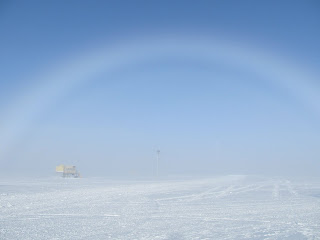
No it's not raining, that's a fogbow framing the Mobil Science Facility (MSF).
With the resultant warm weather more visitors are scheduled to come to Summit. I thought since I'll be the one to give tours of the MSF, which houses the ICECAPS instruments, it would be a good time share with you the measurements being done here.
Overall, ICECAPS is a four year project to record cloud, radiation and precipitation properties over the Arctic ice sheet. Basically measuring the atmospheric state of the area from the ground looking upwards.
Nearest and dearest to my heart are the Microwave Radiometers.
 These instruments are a part of the project operated by the University of Wisconsin. I've helped to create quicklook images and ensure the data is calibrated.
These bad boys can measure the amount of water vapor in the air (not much) and estimate how much liquid water is condensed into clouds. In addition, the MWRs will be utilized for my master's thesis to retrieve temperature profiles over the ice sheet in order to investigate how these profiles evolve in the presence of various clouds.


I launch a radiosonde every morning at 9:15 local time and earlier if there is a flight coming in.
These weather balloons give a snapshot profile of the atmosphere.
The PAERI instrument, operated by the University of Idaho, is an infrared spectrometer that scans from 3-18um, having the ability to retrieve temperature profiles up to the cloud base and discriminate between ice or liquid phase clouds.

The Ceilometer and the Micro Pulse Lidar (MPL) are similar instruments that detect cloud height. The ceilometer is much better for detecting the low level clouds and is actually used for the incoming flights to make sure visibility is acceptable for landing. The MPL is great for detecting cirrus clouds in addition to the low level mixed phase clouds.
 These laser based instruments look up through windows which I check every day when I do my rounds on the roof of the MSF. Pictured here is the CAPABL window, operated by the University of Colorado, which measures backscatter off particles such as aerosols and ice particles of various orientations. The green wavelength laser is powerful enough to damage the eyes so don't look directly down the hatch.
 The POSS sensor (right) is a precipitation sensor that can work in conjunction with the radar (below).
 This 8mm Doppler Radar is cloud sensitive and can see snowfall events in great detail. Unfortunately the radar was broken when I got here and is the only instrument that isn't operating. In July the replacement parts should arrive and I'll get to reassemble and recalibrate the system. Good stuff except I haven't seen the software yet and haven't worked with waveguides before. Should be interesting, I am looking forward to it.
If you are still with me, the last instrument is a sodar which is good for measuring the speed of the boundary layer, giving a sense of the turbulence and how the surface interacts with the lowest level of the atmosphere.
 The sodar chirps a few meters away from the MSF. It is the white box structure, while the tower in the distance samples air and boundary layer properties for a different project.
Plenty to keep me busy, but if things are running smoothly I can launch a radiosonde balloon and do my rounds before lunch, leaving the afternoon to either do research or troubleshoot lingering problems.
After a nice few weeks of settling in I think I'm prepared for what the next month has in store. This will include multiple visits from our source of funds, the National Science Foundation, as well as tours by high school and college honors students and possibly some reporters. I'll have to time my showers well, I know I'm due for one tonight.
No comments:
Post a Comment